
East Carolina University at Biscayane National Park

3D Printing an Archaeological Site Map By Annie Wright June 8, 2016
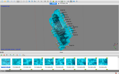
3D model of Pillar Dollar site created in Agisoft Photoscan (image by J. McKinnon 2016). See the large version of this image here.
3D Modeling an archaeological site through the use of photogrammetry allows archaeologists and the public alike to explore a site in new and innovative ways. The use of 3D imaging and modeling technology in archaeology is a dynamic part of the field with room for constant improvement. These techniques have the potential to vastly increase knowledge, both scientific and public, of underwater cultural heritage. Creating 3D models of submerged cultural heritage benefits both archaeologists and the public in a number of ways. Archaeologists are able to record information for relatively low cost, while leaving heritage in situ (in its place) for future study. Additionally, 3D models of shipwreck sites and other artifacts allow the non-diving public to experience underwater cultural heritage virtually. There is also the potential to 3D print models and utilize them in museums and other public outreach settings, without having to take artifacts through the expensive and time-consuming process of conservation.
At the Pillar Dollar Wreck site, we have been utilizing photogrammetry to map the site in 3D. This involves laying a series of coded targets around the wreck to increase accuracy of the model, and then following a flight pattern to take as many photos as possible of the wreck in one sweep. In this instance, we took approximately 630 photos of the site while following a U-pattern across its entirety. Upon returning to Broad Key, these photos were imported into a program called Agisoft Photoscan, which creates high quality 3D models. We followed a workflow within the program taught to us by Dr. Kotaro Yamafune during a photogrammetry workshop held at ECU this spring.
My personal thesis research involves developing and testing methods to 3D print in situ submerged heritage. For the Pillar Dollar Wreck excavation project, I plan to print a 3D site map from the photogrammetry model created that shows the wreck site in full color and texture. This process is as simple as creating the photogrammetric model using Agisoft Photoscan, the same model that will be used for additional interpretation, and adding a few rendering effects in a program called Blender to make it look 100% realistic. The result is a highly realistic, miniature model of the shipwreck site. This model will then be 3D printed to a designated size and shape. /p>
East Carolina University is home to several 3D printers. The ZPrinters, produced by ZCorporation, utilize a starch-based and/or plaster-based powder material to print objects. ZCorp printers are the fastest in the world, and uses a combination of a 24-bit palette of pigments to create a wide range of color.
The ultimate goal of the 3D printing project is to use the printed model in the Biscayne National Park Visitors Center as an interpretive tool. In this way, the non-diving public, or other visitors who may never have access to submerged cultural resources can see a shipwreck site in a realistic manner. One of the most important parts of archaeology is to share our findings with the public- the past belong to everyone. What better way to share than by utilizing exciting technology in new, educational ways?
Previous Next